

2. XLACAH CENOTE, DZIBILCHALTUN Dzibilchaltun's existence was in a sense fore-ordained by its geography on the border between the mangrove swamps, salt deposits and fishing and trading opportunities of the Gulf of Mexico, 20 miles away and the Yucatan's karst crust with just enough topsoil to raise a crop of corn. As important, the settlement was located at the Xlacah Cenote, the largest on the Peninsula, 200m x 150 m at the surface but 60m deep and stretching along a cavern at least 1.5km long. Its central role in the town's founding is attested by its name which means the "old town's sinkhole," providing both an abundant source of drinking water and ready access to the underworld and the supranatural. People of all social classes cast offerings, mostly pottery but also precious stones into its depths, (though there is an unusual lack of human remains.) Today the local Maya don't hesitate to use it as a swimming hole, nor do tourist sweltering after hours trudging along the city's unshaded, far-flung sacbeob plural of sacbe or "white way," named after its sandstone paving covered in lime.)
1. DZIBILCHALTUN AND MAYAPAN
3. TEMPLE OF THE SEVEN DOLLS (TEMPLE OF THE SUN,) DZIBILCHALTUN, (c. 500 CE) The Temple of the Sun was discovered only in 1946 when some masonry was found protruding from a rubble mound on the outskirts of Merida. Like many Mayan temples this one appears to have had multiple building stages. The earliest dating around 300 B.C.E. gave the temple its name when some flints and clay figurines were found, probably part of its dedicatory cache. (They are in the site museum and shown on slide 12.) The teocalli or temple we see today dates from the Early Classic period around 500 C.E. and consists of two terraces 23m and 8.5m square with al slope of 61 degrees, radial (on all four side) staircases and alfardas (ramps or low balustrades) beside them. The cella occupies the entire upper terrace and has doors on all four sides with a corbel-vaulted corridor surrounding them and a central light shaft open only on the east and west. It has a large openin gon the south which may have had some astronomical function, as do many of the stelae dotted around the city. But this tower or "cap" may also have functioned simply as a cresteria or "roof comb," a backing for stucco sculpture. Between the ataduras (binding moldings or cornices) bordering the facades, Chac masks were placed over the doors and on the corners with a frieze of snakes and griffins. The temple's most notable architectural feature is the two small windows - surprisingly the only ones in all of Mayan architecture. In light of the Chac masks on the corners, these may have been intended to suggest that the entire east facade was such a mask. Buildings overtly simulating masks were characteristic of the Chenes style of architecture which flourished at a later date in the middle of the Yucatan peninsula. An example would be the western temple at the Pyramide del Aldivino (Pyramid of the Sorcerer) from the 9th Century at Uxmal, the pre-eminent Puuc site.. The temple is otherwise unimpressive considering the pyramids built at the same time at sites in the Peten such as Tikal or Palenque. It has reminded some of a birdhouse (although possibly one for a "feathered serpent.") It is perhaps best known for the crowds which gather at sunrise on the vernal equinox to see a blaze of sunlight pierce the east and west doors. (At sunset on the same days 1oo km to the east, the dedicated tourist can see serpents slithering down the balustrades of "El Castillo," the Temple of K'uk'ulkan at Chichen Itza. This accounts for the temple's incongruous association with the sun despite the prominent presence of Chac, the god of rain and overcast skies.


4. TEMPLE OF THE SEVEN DOLLS (TEMPLE OF THE SUN), DZIBILCHALTUN (c.500) When discovered, the temple was entirely filled with rocks and covered by the ruins of larger pyramid built on top of it around 800. Archaeologists removed the later temple but left its terraces on the south to give some idea of its dimensions. The terraces of this third temple were extended to the bottom of the steps of the second on each of its four sides resulting in a Greek cross shape with flights of steps projecting in front of them visible to the right in this photo.. It required four terraces just to reach the top of the old temple's facade and a fifth to cover the central shaft; the space remaining for a cella would have been quite small. The stonework as elsewhere at Dzibilchaltun is characteristic of the Peten not the nearby Puuc hills.. An idea of what may have been intended is provided by Structure 36, (see slide 8,) in a sense, paired with it at the opposite end of the 1.3km sacbe stretching to the west. It has six terraces but only a single southeast- facing staircase; the third Temple of the Sun may have had just one flight of steps on the south as well.

5 SITE PLAN, DZIBILCHALTUN At first glance, the site plan of Dzibilchaltun might seem reminiscent of a Roman castrum with an east-west decumanus, Sacbeob 1 and 2 ( blue) and a north-south cardo, Sacbeob 3 and 4 (lavender) with a forum at their junction (the Central Plaza.) Closer inspection reveals that most lines are not strictly orthogonal; but have a slight "clinamen" or inclination, a characteristic of Mayan scenographic urban design. At Chichen Itza, for example, the eye is led around the site from the ball court around the North Plaza, past El Castillo to the Ossario and Las Monjas in the southern zone, in a carefully staged, unfolding series of views. . At Dzibilchaltun the major temple complex, the Temple of the Seven Dolls ( tTemple of the Sun) is deliberately set off 1.3 km to the west of the central Xlacah Cenote to reorient or extend the site in that direction and provide a theatrical setting for its annual astronomical spectacle. One next notices that the first building at the northeast corner of the city's Central Plaza containing the cenote and leading to its other quarter, the pyramid designated Structure 36, is not only angled to the southwest but juts into the center of the sacbe. This directs attention towards the Temple of the Sun or towards the cenote and Central Plaza depending on which direction one is coming from. Structure 44, a long administrative building like the Honoch-nah at Edzna, forms the plaza's southern side of the Central Plaza moves the eye to the west and the cenote. There another platform angled to the southwest provides the joint between the Central and the smaller, denser and older South Plaza. It in turn points to the plaza's southwest corner and a crowded quadrangle, where another sacbe forms its southern limit. This road leads to a large radial pyramid, Structure 89, which is angled to the northwest, opening onto the large West Plaza. Thus a series of sightlines traces a diagonal (red ) across the city from the Temple of the Seven Dolls in the northeast to the Plaza in the southwest crossing the cenote at the major north south artery (lavender.)
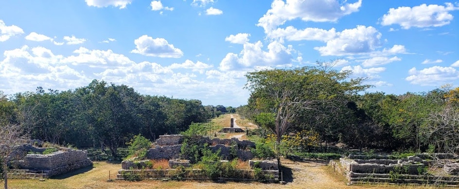
6. SACBE 1, DZIBILCHALTUN The Temple of the Seven Dolls, located l.3 km east of the Xlacah Cenote and the city center, was not placed there for daily visits and may have been the precinct of a priestly cult. At the same time, it is clearly visible at the end of the sacbe leading from the population centers of the city (in the distance in this photo taken the temple.) Dzibilichaltun, as shown on the site plan, was comprised of separate quarters at some distance from each other with a roughly orthogonal network of sacbeob connecting them. In front of the Temple of the Seven Dollls are six back-to-back nearly identical buildings (structures 4 - 9) with rooms or cells appropriate for the temple's priest. In the near distance is one of the stela or gnomon, Structure 12, the upright of a sundial which are characteristic of the city. In addition, a number of small ancillary buildings, including a pyramid, cluster around the temple and are presumed to have fulfilled an astronomical function (though what exactly has yet to be discovered) . Most of the alignments at Dzibilchaltun are fairly straightforward and solar; indicating its early date before the Venus (Quetzalcoatl) cults of Central Mexico penetrated the Mayan peninsula. Many temples were also situated above small openings or cenotes regarded as entrances to the underworld. Since it has never been fully explored the Xlaiek Cenote's cavern might extend this far.

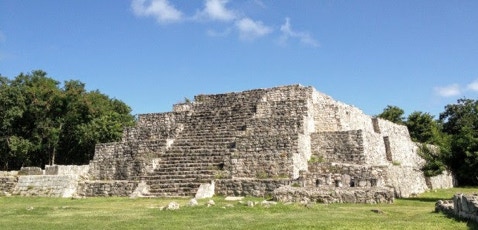
8. STRUCTURE 36, DZIBILCHALTUN (14TH CENTURY) Structure 36 anchors the northeast corner of Dzibilchaltun's Central Plaza. It juts into Sacbe 1 coming from the Temple of the Seven Dolls at an angle pointing to the Cenote Xlacah. Here the road divides: one leads to the cenote, South and West Plazas; the other continues to the west to residential precincts. The pyramid is not entirely what it seems: from the front it is a convincing version of a classic six tier pyramid with central staircase, once fronted with alfardas or border strip with tableros or perpendicular walls marking each terrace. The rear of the pyramid however is much longer than its front and composed of massive layers of stone which act as buttresses against subsistence. Thus the building is more a tall platform with a staircase on the front, resembling the Southwest Temple at the Great Acropolis at Edzna. The rites performed on this terrace would not have been visible from the Central Plaza which would have made them all the more divine "mysteries."
7. GNOMON, (STRUCTURE 12,) DZIBILCHALTUN This stela acts as gnomon, called In Yucatan, Lakuntun, a "big rock" or monolith and thought to be inhabited by K'awil or God K, the "manikin scepter" god who could turn a stela into a divination mirror where supernatural beings and ancestors could communicate with the king, especially on Koz Zumic Kin, the two zenithal days each year at cities in the tropics when the sun at noon is directly overhead, (May 27 and July 18 at Dzibilchaltun) and the gnomon casts no shadows. On the winter solstice the sun strikes this gnomon at a 45 degrees and so the length of its shadow and height are exactly the same. The ability to predict such events was central to the power of the priests and Mayan god kings. DZIBILCHALTUN'S COSMOLOGICAL SIGNIFICANCE Dzibilchaltun in Yucatecan means "the place with writing on flat stones," a reference to stelae and gnomons such as this. This name, however appropriate, was given it by the Spanish in the late 17th Century. The city's actual name was Ichkantiho, "the sky at five," most likely was a reference to Na-Ho-Kan, "The House at Five," the location in the Mayan creation myth where at the Maize god's command the Paddler Gods placed the Jaguar Stone Throne, the first of three making up the Cosmic Hearth, believe to be the three stars in the belt of the constellation Orion. The Maya distinguished six dimensions, the four cardinal plus the zenith and the nadir. The "sky unbilicus," represented by entwined snakes, (analogous to "vision serpents,") linked Mayan royalty to the gods in the heaven and their ancestors in the Underworld. This snake is sometimes shown as wound around the branches of Wakah-Kan, the "World Tree," the "Sky at Six," or "Raised up Sky" the Mayan name for the Milky Way, rising to the zenith or sixth dimension. Five may accordingly refer to the navel of the world, the crack in the cosmic turtle's made by Chac at the time of the Maize god's resurrection from Xibalba. It was regarded as, the "ol" or portal to the Underworld, Sak-Bak-Nakan, or "White Bone Snake," located at the foot of the Milky Way and World Tree. This association with the place of creation may have led the Itza in K'atun 11 Ahwa (771-791; 9.18.0.0.0.11 Long Count) to create their alliance for ruling the northern Yucatan at Ichkantiho, the counterpart in the present of Na Ho Kan, These two creations are juxtaposed and equated at the Lower Temple of Jaguar at Chichen Itza's ball court, thus legitimizing at the moment of creation, the Itza's eventual rule over the Maya.
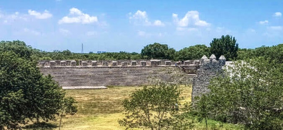
9. STRUCTURE 44, DZIBILCHALTUN (14th CENTURY) Opposite structure 36, across the Central Plaza is another building with a counterpart at Edzna, the Honoch-Nah or "Big House" built in 464. Like it, Structure 44 consists of a broad flight of steps with the piers of a suite of rooms running along its top; their vaults have also collapsed or the roof may originally have been made of thatch. Like the Honoch-Nah, these chambers would have been used as offices for public business at Dzibilchaltun. Similarly, its steps could have functioned as seating for rituals conducted in the Central Plaza which this photo looks across from Structure 36. That the plaza was used for spectacles is further suggested by the small stone building in the foreground. This was an open-air altar built by the Franciscan missionaries, soon after the conquest, where the Mayans of the town could see the mystery of transubstantiation of the new religion, Christianity, performed. Such informal churches for large audiences were common in the Yucatan during the rapid conversion of the Amerindians from their centuries' old beliefs to Catholicism. The Spanish saw this as an urgent task both for the salvation and subjugation of their new subjects, The Mayans syncretized the new religion with the old so the priests were often unsure who was being worshipped - neither, probably could the Maya. Oddly both the new and traditional religions were centered on gods who died to redeem humanity but who required parallel sacrifices of the faithful. The Conquest devastated a civilization already in long-term decline (at least since the abandonment of Uxmal and Chichen Itza in the first half of the 10th Century. making conversion more attractive. During the first hundred year "contact period" between Mesoamerica and Europe, it is estimated that the indigenous population declined from 11 million to 1.5 million largely through pandemics of everyday diseases in the Eastern Hemisphere for which the Maya had no immunity. This must have been at least as demoralizing as the Conquistadors' exploitation of an already subject population.
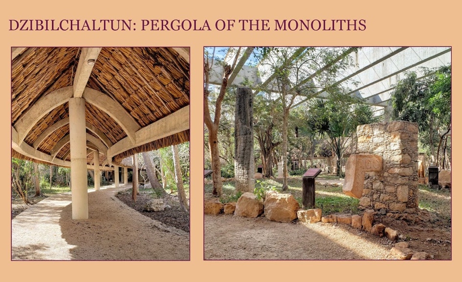
10. PERGOLA OF THE MONOLITHS, MUSEUM DZIBILCHALTUN What Dzibilchaltun lacks in impressive buildings it compensates for by its outstanding display of Mayan sculpture from sites across the peninsula. A shaded walk (on the left) thatched like a traditional "xanil nah" or Mayan house leads to the "Pergola of the Monoliths," a sculpture garden and a indoors museum. (right.) In the foreground is a nose (actually upper lip) from a mask of Chac, the rain god, especially venerated in the arid Yucatan, from the Temple of the Seven Dolls: It is decorated with solar disks and a K'awil, the "mannikin scepter" or "flare" god, a symbol of royal authority carried by all Mayan kings on stelae, attesting to the totemic powers invested in both the stone and sovereign. To its left, is a tall stela from Quintana Roo on the Caribbean (eastern) coast of the peninsula, entirely covered with a calendrical hieroglyphic inscription which dates it to the equivalent of 594 C.E., still during the Early Classic period (300-600)