XII. SYNTHESIS: Angkor Wat
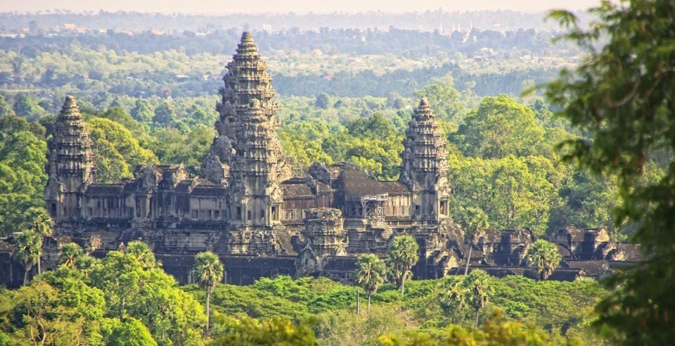

Books have been written to explain the many enigmas of Angkor Wat. Some have argued that it faces west rather than the more orthodox east because it was dedicated to Vishnu who was associated with that direction, and its commissioner, Suryavarman II’s, posthumous name was Paramavisnuloka, an avatar of that deity. Others have contended it was a funeral monument like the pyramids of Giza because the west was traditionally associated with sunset, death and a return to the dark womb – or “womb chamber,” the garbagriha. Archaeologists have more recently suggested the temple may have functioned as an observatory, since the king was named after the Vedic sun god, Surya, and have painstakingly counted the number of windows, columns and steps between every part of the temple to demonstrate they were calibrated with the path of the sun or moon. Angkor Wat assuredly symbolized Mt. Meru, center of the Hindu universe, like every other :temple mountain,” but it has also been suggested it might have represented Mt. Mandara, the legendary pivot Vishnu used in the “Churning of the Ocean of Milk” to coagulate the elixir (butter?) of immortality in one of the most often illustrated Khmer myths. The city and empire swirling around this temple mountain at its center would then re-enact each day the same mythopoeic urbanism as the bridge and moat around Jayavarman VII’s Angkor Thom, a symbol of the prosperity resulting from industrious cooperation by the empire’s diverse people. This myth, in fact, is illustrated in the celebrated bas relief murals of the southern half of its 1st eastern gallery, while nearby, in the western half of its southern gallery, is a procession of Suryavarman II’s court and army, perhaps to suggest a parallel. Between the two, however, is a carving of the heavens and narakas, the gruesome hells; did these demonstrate the rewards and punishments meted out to those who embraced or rebelled against the murals’ symbolic messages? The following few paragraphs of analysis do not attempt to resolve such conundrums rather they use Angkor Wat to synthesize or knit together two threads in the evolution of Khmer temple mountain architecture which have emerged in this introduction – asymmetry and cruciform expansion.
There is no dispute that the temple is the largest stone building and religious structure ever built or that Angkor Wat was not its name, however apt it is may seem – a macaronic Sanskrit-Khmer phrase, hybrid like its architecture, meaning “the city in the shape of a temple.” It is difficult today, when the temple sits in isolated splendor within a landscaped archaeological park, to imagine it the hub of an intensively cultivated conurbation, divided into orthogonal plots linked by an extensive network of canals and roads indicative of a high degree of central planning. The Aztec capital of Tenochtitlán, set in the middle of Lake Texcoco, surrounded by its so-called “floating gardens” or chinampas which so amazed Cortez in 1519 and still are visible at Xochimilco, may offer a more accurate picture of ancient Angkor than its scrupulously restored, but decontextualized, present monuments. The area immediately adjacent to the temple has been estimated to have had a population approaching half a million, making it one of the largest cities of its day. The temple’s rigorous plan reached beyond the three terraces analyzed in the following diagrams, across the 82-hectar 4th enclosure, over the 190m moat to the other temples in the Angkor area and, beyond them, the major religious and commercial centers of the Khmer Empire – the temples at Beng Mealea, Banteay Chhmar, Phnom Chisor, Preah Vihear, Phnom Rung and Phimai. In 2015 over a billion LIDAR photographs of the Angkorian heartland confirmed that the temple’s grid extended into the densely populated rural zones around it.
FIGURE 17: ANALYSIS OF SITE PLAN, ANGKOR WAT (1113-1150)
3RD OR UPPER TERRACE, ANGKOR WAT (1113 – 1150)

THE NARAKAS OR HELLS, 1ST GALLERY SOUTHEAST, ANGKOR WAT (1113 - 1150)
1. Vishnu shrine and central tower
2. 3rd (upper) terrace
3. Cruciform pavilions (4)
4. 3rd gallery (open colonnade)
5. 2nd (middle) terrace
6. 2nd gallery (apsaras)
7 1st (lower) terrace
8 1st gallery (bas relief murals)
9. 4th (outer) enclosure
10. 2nd terrace “threshold line” (broken red line)
11. 1st terrace “threshold line” (broken black line)
12. 2nd terrace “cruciform walkway”
13. 1st terrace “cruciform cloister”
14. Towers (9, shaded orange)
15. 3rd west triple gopura (liturgical entrance)
16. “Libraries” (4)
17. Causeway over 4th (outer) enclosure and gallery from the moat
18. Eastward offset
9 x 9 = 81-pada paramasayika mandala
Angkor Wat has been described succinctly as a pyramid with three galleries (4, 6,10) around three terraces or levels (2, 5, 7) with a panchayatana or double quincunx of towers (circles) at its center and the four corners of its 3rd and 2nd terraces (2, 5) for a total of nine (a double quincunx.) The 1st terrace (7) is surrounded by a vaulted gallery (8) with an open, outward-facing colonnade containing the renowned eight narrative bas reliefs, over 600m long and more than 2m high. These murals, unlike Borobudur’s, do not follow any readily discernible sequence or didactic program; they may refer to scenes across the terrace or even points beyond the temple, terrestrial and sidereal, or to nothing but themselves. Behind this gallery, the wide lawn of the 1st terrace (7) is linked by a “cruciform cloister” (13) to the 2nd gallery (6) and terrace (5) which presents an austere contrast with the 1st, paved entirely in stone with towering, canyon-like walls, its somber atmosphere lightened only slightly by 1024 (210) apsaras, similar to aurai or wind nymphs in Greek mythology, carved on its galleries, each slightly individualized, denizens of a more ethereal world than the bellicose scenes depicted in the 1st gallery below. The 2nd terrace is in turn connected by a second, raised “cruciform walkway” (12) to the central staircase up to the west range of the 3rd terrace (2,) which climbs at a 70% incline from the shadowed depths of the 2nd terrace (5) to the open colonnade of the western gallery (4) of the 3rd terrace (2) with its spacious views of the surrounding city and countryside. The 3rd terrace (2) repeats the pattern and dimensions of the cruciform cloister, except its is an open “cruciform colonnade” whose arms lead via four cruciform pavilions (3) to the central tower (1) of the double panchayatana. This contains the temple’s sanctuary or cella, a redented Greek cross with four porches, dedicated to Vishnu rising above from the 3rd terrace (2) in three stages, repeating the three levels of the temple pyramid itself and therefore, in a sense, an aedicule of it. The shrine is saptaratha, with seven redents or facets per quadrant, topped by a shikhara with five tiers or talas which repeat in ever-decreasing layers the outline of the shrine beneath them. It soars 213m above the 1st terrace, higher than the flêche of Notre Dame de Paris (prior to its incineration in April, 2019.)
The three terraces can as usual be associated with the three worlds, lokas or dhatus, of Hindu and Buddhist cosmology which also divide the terraces at Borobudur and the Baphuon; in Hinduism, the underworld, earth and heaven; in Buddhism, the kamadhatu or “desire realm,” the world of myth, history and the Vedic gods, portrayed on the 1st gallery (8) bas reliefs; the rupadhatu or “form realm” of radiant, self-delighting creatures, symbolized by the apsaras of the 2nd gallery (6;) and the arupadhatu or “formless realm,” states of pure awareness or energy, without form or location, perhaps suggested by the open colonnades (4) of the 3rd terrace. In a further analogy, the bas reliefs of the 1st gallery (8) could be correlated with the profane or samsaric world of outward actions of Hinayana (Theravada) dharma, the laws of right conduct; the apsaras of the 2nd, with the world of inward, self-reliant consciousness of the Mahayana sadhanas, yogas and meditative practices; leading to the 3rd, the Vajrayana or Tantric realm of “effective means,” resulting in an experience of one’s own transparency, sunyata or emptiness, and providing a glimpse of the “world beyond thought.”
If a 9x9-pada paramasayika mandala is drawn over the 1st or lower terrace, its 1st and 2nd squares of 32 and 24 padas respectively will fill, on its west, the space between the “threshold lines” of the 1st and 2nd terraces (11,12) and, on its east, the space between the 1st and 2nd galleries (8,6.) Similarly, its 16 devika padas will fill the area around the square 3rd terrace (2,) on the west, between the “threshold line” of the 2nd terrace and the gallery of the 3rd (10,4) and, on the east, between the galleries of those two terraces (6,4.) The 3rd terrace (2,) with the redented, cruciform shrine and shikhara (1,) occupy the nine middle or Brahma padas. The proportions of Angkor Wat’s 1st terrace are roughly 53 x 46 or 86.78%, that is, 13.22% longer than it is wide. (For those who share the Khmer fascination with astronomy, it may seem more than coincidental that Angkor Wat’s latitude is 13.24 N.) The temple displays the asymmetry of most other Khmer shrines, although because it faces west its north-south axis is set-back to the east. If “threshold lines” are drawn for the 1st and 2nd terraces, that is, at the point where that terrace’s length equals its width (broken lines 10, 11,) the “threshold line” of the 1st terrace (11) falls midway between the western (outer) edges of the 1st and 2nd galleries (6,8) and equals the length of one of the arms of the square “cruciform cloister” (13) linking them. The “threshold line” of the 2nd terrace (10,) like that of the 1st, also falls at the edge of a second, smaller cruciform structure, an elevated “cruciform crosswalk” (12) linking the 2nd terrace with the lip or projection of the 3rd gallery (4.) This “cruciform crosswalk’s” (12) northern and southern arms connect the two small “libraries” (16) of the 2nd terrace; its western arm extends to the western (outer) edge of the 2nd gallery (6) and its eastern arm to the outer edge of the 3rd terrace’s protuberance at the top of the stairs from the 2nd. The same, seemingly contrived, architectural assemblage had already been noted on both the eastern and western sides of the 1st terrace of the Baphuon (4 on figure 16.) It may even have existed in embryo in the enclosure of the first Khmer temple mountain, Ak Yom (700-725) where a raised, T-shaped crosswalk leads from the primary or eastern entrance to the steps of the pyramid’s 2nd level and connects two, small, facing guardian shrines (7 on figure 12.) The equal arms of the “cruciform walkway” (12) at Angkor Wat are, not coincidentally, half the length of those of its “cruciform cloister (13,) and, therefore, also half those dividing the quadripartite 3rd terrace (2) whose length and width are therefore twice those of the “cruciform walkway.” Thus the 3rd terrace (2) is itself a square, “cruciform colonnade” isomorphic with the “cruciform cloister” of the 1st (13) and the only terrace to display four-way symmetry around the two axes. The three terraces’ eastern quadrants form nested squares around the axial crossing; adding the asymmetrical sections on the west, however, the 1st and 2nd terraces (7, 5) form rectangles with proportions of roughly 5/9 and 2/3 respectively.
Angkor Wat can be divided by a modular unit with a
remainder, a central feature of both Khmer and Indian
architecture. The temple’s structures are assembled from
this unit and the remainder which then form a symmetrical
sequence from west to east.(excluding the asymmetrical
eastward off-set equal to two modular units.) Readers who
thought elementary algebra was safely in their past may
wish to skipthe remainder of this paragraph. The modular
unit is derived from the critical difference in most Khmer
temples between its length (here 215m) and width (187m) -
the distance between its western edge and its “threshold line”
or 28m; the modular unit is half that length, which equals the
distance between the temple’s north-south axis and its
midpoint, or 14m, labeled “a” on the diagram at right. The
difference between the temple’s length and width, 28m,
divides its length, 215m, into seven equal parts or 14a, for
a total of 196m. This leaves a remainder of 19m which, if
also divided into two parts, yields a unit of 9.5m, labeled “b”
on the diagram. Thus, the length of the temple can be
expressed as 14a + 2b. Analyzing the temple from the west,
since the threshold line of the 1st terrace is 2a long and falls
on the crossbar of the cruciform cloister, the distance between
the 1st and 2nd terraces' western edges, the width of the cruciform cloister, equals 4a. Since the difference between the 2nd terrace's length and width is half that of the 1st or 14m, the distance between its western edge and threshold line equals a and falls on the north-south arms of the "cruciform walkway;" so the total distance from the western edge of the 2nd terrace to the top of the central stairs to the 3rd is 2a. This formula could then have been repeated for the 3rd terrace, producing a rectangle whose length was 1/2a longer than its width. The architects of Angkor Wat, however, decided that the 3rd terrace should be square and isomorphic with the cruciform cloister, therefore 4a wide and 4a long, centered on the axial crossing. The half of the cruciform cloister east of the threshold line is 2a long; the "cruciform walkway" also 2a and the western half of the 3rd terrace, also 2a, leaving a gap between the eastern edge of the "cruciform walkway” at the top of the stairs to the 3rd terrace and the western edge of that terrace's colonnade of b. (12a +2 b = a side of the mandala square, the distance from the "threshold line" of the 1st terrace to that terrace's eastern wall; therefore 6a + b or half that, equals the distance from the "threshold line" to the north-south axis.) This gap is filled by the platform or lip projecting between the 1st west gopura, the central gopura of the 3rd terrace's western colonnade, and the top of the steps from the 2nd, (the eastern arm of the "cruciform walkway.”) Continuing east along the west-east axis from the 3rd terrace, the distance between its eastern edge and that of the 2nd terrace must equal the difference between the "threshold line" of the 2nd terrace and the western edge of the 3rd, in other words, half the length of the "cruciform walkway" or a, plus the westward protuberance or b, thus a + b. The remaining distance between the eastern edges of the 2nd and 1st terraces would then equal the difference between the overall length of the 1st terrace or “3rd enclosure” and e temple, 14a + 2b, and the distance from its western edge to the eastern edge of the 2nd terrace, 4a (the cruciform cloister) plus 2a (the "cruciform walkway") plus b (the protuberance) plus 4a (the 3rd terrace) plus a + b (the distance between the eastern edges of the 3rd and 2nd terraces) or 11a + 2b, leaving 3a as the width of the 1st terrace on the east . Thus the length of Angkor Wat could be expressed as (aa/aa)(aa)(b)(aaaa)(ba)(aaa) with the parentheses representing the different structural units and the forward slash its asymmetrical eastward offset or threshold line, (11 on figure 17,) leaving the symmetrical sequence aaaabaaaabaaaa.

SURYA (OR SURYAVARMAN II,) 1ST GALLERY SOUTHWEST, ANGKOR WAT (1113 - 1150)
